Saturday 19 December 2015

Geminidien tähdenlentoparvi ja 6.12. tulipallo SGO:n tulipallokamerassa

Tänä vuonna säät suosi viime vuotta paremmin Geminidien tähdenlentoparven havainnointia Lapissa. Ainoastaan tiistaiaamuyön 15.12. tähdenlennot jäi pilvisen taivaan taakse. Tulipallokameran automaattinen eventtien tunnistusohjelma poimi 12.-16.12. välisenä aikana yhteensä 75 eventtiä. Näistä 12.-13.12. välisenä yönä tallentui 24 eventtiä ja 13.-14.12. yönä  35 eventtiä, kun tyypillisesti kamera tallentaa 3-5 eventtiä yötä kohti, johon mahtuu myös satelliitteja ja kirkkaita revontulia.

Pimeän ajan (15UT-06UT) tunnittaisten maksimipikseliarvokuvien summa SGO:n tulipallokamerasta 12.-16.12. 2015 väliseltä ajalta. Kuvassa erottuu myös 14.12. illan kirkkaimmat revontulet.


 SGO:n tulipallokamera on WATEC 902H3 (1/3")
 varustettuna 2.8mm laajakulmalinssillä antaa
 noin 65° kuva-alan taivaalta.


SGO:n tulipallokamera toimii revontulikameran rinnalla. Kameralla on tarkoitus tukea SGO:n muita havaintoja ja aineisto on yhteistyökumppaneiden käytettävissä. Samalla kamera täydentää Lapin muuten harvaa automaattista havaintoverkkoa. Etenkin ennen URSA:n Taivaanvahti-järjestelmää SGO sai runsaasti havaintosoittoja kansalaisilta. Tällä hetkellä SGO käyttää Eric Stamplesin (Uppsalan yliopisto) kehittämää ohjelmistoa Ruotsin tulipallokameraverkolle, jota myös SGO:n yhteistyökumppani IRF Kiirunassa käyttää. Kyseinen ohjelmisto tallentaa vain tunnistetut eventit.

Tulipallokameran monitoroima taivas merkittynä punaisella 
laatikolla UCL:n revontulikamerakuvaan. Tällä hetkellä kamera on suunnattu
lähes zeniittiä kohti.
Useimmat URSA:n Taivaanvahti-järjestelmään raportoidut tulipallot jäävät SGO:n kameran kuva-alan ulkopuolelle. Laajakulmalinssin vaihto kalansilmälinssiin auttaisi asiaan ja on suunnitelmissa. 

6.12. 2015 SGO:n tulipallokamera kuitenkin tallensi osittain Pohjois-Suomen taivaalla havaitun kirkkaan tulipallon, josta tehtiin myös äänihavainnot Kittilässä ja Sodankylässä. Kyseinen tulipallo tallentui 4 sekunnin ajan SGO:n kameraan.


Tuesday 8 December 2015

Effects of solar wind high-speed streams on the high-latitude ionosphere: Superposed epoch study

Our study of the effects of solar wind high-speed streams on the high-latitude ionosphere, based on data from the SGO ionosonde during the years 2006–2008, has now been accepted for publication. An early-access version is available here, and the reference is:
Grandin, M., A. T. Aikio, A. Kozlovsky, T. Ulich and T. Raita (2015), Effects of solar wind high-speed streams on the high-latitude ionosphere: Superposed epoch study, J. Geophys. Res. Space Physics120, doi:10.1002/2015JA021785.

Here is the abstract:

Solar wind high-speed streams (HSSs) are the most important source of geomagnetic disturbances during the declining phase of the solar cycle. Their ionospheric response, especially at high latitudes, is not fully understood yet. We carried out a phase-locked superposed epoch analysis to study the effects of HSSs on the high-latitude ionospheric F region, using data from the Sodankylä ionosonde (L = 5.25) during 2006–2008. We found that the F layer critical frequency foF2 decreases between 12 and 23 magnetic local time (MLT) in summer and around equinoxes for several days. Our interpretation, supported by numerical estimations, is that increased electric fields in the evening sector of the auroral and subauroral regions create ion-neutral frictional heating. Frictional heating will increase the loss rate of O+ due to two reasons. The first one is neutral heating producing thermal expansion of the atmosphere and enhancing N2 and O2 contents at the F region peak. The second one is ion heating which may occur under strong enough electric fields (about 50–60 mV/m), leading to enhancement of the reaction coefficients. An increase in foF2 is observed in two different MLT sectors. First, a short-lived foF2 increase is visible during all seasons near noon on the first day after the arrival of the HSS, possibly triggered by the compressed solar wind plasma pressure pulse, which may produce particle precipitation from the dayside central plasma sheet. Second, foF2 is enhanced for several days in the morning sector during equinoxes and in winter. We suggest that this is caused by the low-energy tail of particle precipitation.


Variations of foF2 and max(foE, foEs) values compared to background values, by magnetic local time and day number relative to zero epoch. ©2015. American Geophysical Union.


Saturday 5 December 2015

Sodankylä ionospheric tomography dataset 2003–2014

At Sodankylä Geophysical Observatory, we have made continuous ionospheric tomography measurements for one solar cycle. Because of this big database, we have written a dataset paper, and, the paper is now online as a discussion paper in Geoscientific Instrumentation, Methods and Data Systems (an EGU journal).
The number of satellite overflights over the 
whole observation period with respect to 
minimum threshold elevation. 

In the paper, we show that ionospheric tomography results are modulated by the solar cycle, which can be seen from the analysed data. We have altogether measured over 66,000 flybys of the Russian COSMOS beacon satellites. For the analysis, we used only north-to-south flights, because they are along the SGO ionospheric tomography chain.

In the figure below, we have plotted the analysed total electron content (VTEC) values over Kokkola, Finland (averaged from 11-14 MLT). These are compared to the well-established Sun activity indices, the sunspot number and the solar flux index F10.7.

The paper is fully citable as:
Norberg, J., Roininen, L., Kero, A., Raita, T., Ulich, T., Markkanen, M., Juusola, L., and Kauristie, K.: Sodankylä ionospheric tomography dataset 2003–2014, Geosci. Instrum. Method. Data Syst. Discuss., 5, 385-404, doi:10.5194/gid-5-385-2015, 2015.

... and here's the abstract:

Sodankylä Geophysical Observatory has been operating a tomographic receiver network and collecting the produced data since 2003. The collected dataset consists of phase difference curves measured from Russian COSMOS dual-frequency (150/400 MHz) low-Earth-orbit satellite signals, and tomographic electron density reconstructions obtained from these measurements. In this study vertical total electron content (VTEC) values are integrated from the reconstructed electron densities to make a qualitative and quantitative analysis to validate the long-term performance of the tomographic system. During the observation period, 2003–2014, there were three-to-five operational stations at the Fenno-Scandinavian sector. Altogether the analysis consists of around 66 000 overflights, but to ensure the quality of the reconstructions, the examination is limited to cases with descending (north to south) overflights and maximum elevation over 60°. These constraints limit the number of overflights to around 10 000. Based on this dataset, one solar cycle of ionospheric vertical total electron content estimates is constructed. The measurements are compared against International Reference Ionosphere IRI-2012 model, F10.7 solar flux index and sunspot number data. Qualitatively the tomographic VTEC estimate corresponds to reference data very well, but the IRI-2012 model are on average 40 % higher of that of the tomographic results.

VTEC values over Kokkola averaged from 11-14 MLT 
versus corresponding IRI-2012 model values, 
sunspot number and solar flux index F10.7. 

Friday 4 December 2015

Northern Lights


It's been very cloudy this past month, with few clear nights. Often we saw in our instruments that there must have been brilliant lights on the other side of the clouds, but on the ground there was no chance to see anything. Then, on Wednesday evening (2nd December), there were gaps in the clouds and for a brief moment the lights appeared...

With this photo we wish all of you a very good weekend, and those of you in Finland a very good Independence Day on 6th December, when Finland will turn 98. Hyvää Itsenäisyyspäivää!

Photo: Thomas Ulich.

Friday 13 November 2015

International Incoherent Scatter Radar School 2016

In the near future the EISCAT Scientific Association will face a major instrumental upgrade with the ESFRI Roadmap project "EISCAT_3D: A European Three-Dimensional Imaging Radar for Atmospheric and Geospace Research."

The NSF and EISCAT, in co-operation with the Sodankylä Geophysical Observatory, will run a training course for new users of the incoherent scatter radars, from 24 to 30 July 2016 (Sunday to Saturday). The training course will be held in Sodankylä, where one of the EISCAT VHF remote sites is located.

The course will cover all essential aspects of the current incoherent scatter radar systems, including the science programme. An overview of the existing hardware and software was provided and future plans will be discussed, with an emphasis on phased array radars in preparation of EISCAT_3D.

The course will have a very strong emphasis on practicals, i.e. work in groups of participants on real data. There will be dedicated radar experiments for every group, and the groups will analyse their data and present their results under the guidance of an experienced team of instructors.

For more information, please refer to the radar school web pages.

Deadlines for registration are still undetermined, and we will provide more information soon.

Photo: Craig Heinselman, EISCAT.

Friday 30 October 2015

Observatory Days 2016


On 13–15 January 2016, Sodankylä Geophysical Observatory will host its Observatory Days. It is a great opportunity for space physics researchers to discuss the latest scientific results, current projects as well as future plans for development.

The presentations and discussions will be in English. Interested scientists from any country and institute are therefore welcome to participate!

Please note the deadline for registration and abstract submission: 7 December 2015.

More information is available on the dedicated webpage.

We look forward to welcoming you in January!

Friday 11 September 2015

Aurora pictures 09.09.15

A couple of nights ago, a geomagnetic storm sparked very bright and dynamic aurora over Sodankylä, which lasted for most of the night. Here are a couple of pictures taken from behind the local airport.

At first, it was a bit cloudy, but soon enough the sky became perfectly clear and it was possible to fully enjoy the live show. It went really crazy around 01:00 LT, with very bright pinkish displays below the green arcs, pulsating aurora and dancing structures.


Photos: M. Grandin.

Friday 28 August 2015

FinCOSPAR meeting in Luosto

This week, the XVth meeting of the Finnish space research community, also known as FinCOSPAR, was held in Luosto, about 40 km south from Sodankylä. It was organised jointly by Sodankylä Geophysical Observatory, the Finnish Meteorological Institute and the Finnish National Committee.
Over 50 scientists attended the event, coming from the main Finnish universities involved in space research (University of Helsinki, Aalto University, University of Oulu) and from several space research institutes (Finnish Meteorological Institute, Finnish Geospatial Research Institute, EISCAT). Two Japanese scientists, Prof. Y. Miyoshi from Nagoya University and Prof. T. Tanimori from Kyoto University, also took part in the meeting and presented their work, giving hope for further collaboration.

Motivated and talented Finnish scientists. Unfortunately, the weather did not allow for an outdoor picture.
Photo by T. Ulich.

Some 40 exciting talks enabled to draw a quite broad picture of the current space research in Finland. The presentations were divided into three sessions: 
 1. Earth Observation from Space and Ground – Science and Applications;
 2. Geospace Environment from Space and Ground – Physics and Space Weather;
 3. Solar System and Astrophysics.
The programme also included a panel discussion regarding the future of space research in Finland, involving speakers from the Academy of Finland, Tekes and the National Space Committee.

Thanks to the organising committee for a fruitful meeting!

Wednesday 26 August 2015

All-sky operations started with night time thunder storm

Last night was first observation night with the camera capable to observe the Northern Lights at SGO site station. The observation time is about 4 hours. Instead of the Northern Lights we captured lightning strokes, which is really rare in Sodankylä this time of year when the nights are dark. Past couple weeks has been warmest weeks of the past summer. This ended with cold front travelling over Sodankylä forming heavy thunder shower. The long exposure allowed multiple lightnings in the same frame. The present solar wind conditions provides good change to capture the Northern Lights in the coming night! Other SGO imagers are now in calibration and will be in operation after calibration.

Lightning strikes in UCL Colour image at SGO.

Monday 17 August 2015

Northern Lights Season has started

The first northern lights of the season have been spotted as far north as Sodankylä last night. This has raised the question on when it is dark enough to see them. The northern lights are comparable in brightness to the stars: if you can see the stars, you would see also northern lights, even if the contrast against the bright sky is still very low.

In more definite terms, for the night to be dark enough, the Sun should be some 8°–9° below the horizon. For our scientific all-sky cameras, the limit is -10° solar elevation for at least a couple of hours. This means that it is turned off in mid-April, and could be deployed in autumn as early as late August, but in practice this depends on operational matters, since all cameras are recalibrated and serviced every autumn, which is a collaborative effort with colleagues from other institutes.

In order to give you an idea when the aurora season starts at various latitudes in Finland, we have computed the time of sunrise and sunset as well as the start and end of civil, nautical and astronomical twilight. These are plotted below in "length-of-day/night" diagrams (click to enlarge) for the locations of Utsjoki, Sodankylä, Oulu, Jyväskylä, and Helsinki. The green line in those plots refers to the -10° elevation limit of the auroral camera. These diagrams are explained in somewhat more detail in our article about the Polar Day.

Twilight refers to the time when the Sun is below the horizon, but it is not completely dark. Civil twilight refers to the Sun being between the horizon and -6° elevation. During civil twilight, observations of stars and aurora are possible only using special equipment. When the Sun is between 6° and 12° below the horizon, we speak of nautical twilight, and when the Sun is between 12° and 18° below the horizon we call it astronomical twilight. Once the Sun reaches -18° elevation (18° below horizon) we have complete darkness. Note that this does not happen in Utsjoki before mid-September. But even in Utsjoki, the northern lights season will start in about a week.

Happy aurora hunting!

Length of Day/Night at Utsjoki (click for larger image)

Length of Day/Night at Sodankylä (click for larger image)

Length of Day/Night at Oulu (click for larger image)

Length of Day/Night at Jyväskylä (click for larger image)

Length of Day/Night at Helsinki (click for larger image)

See also: Polar Day.

Friday 31 July 2015

EISCAT_3D Science Case published!

Artist impression of transmitter site.
©National Institute of Polar Research (NIPR), Japan.
During the EISCAT_3D Preparatory Phase project, which was funded by the 7th Framework Programme of the European Commission and which ended in September 2014, the science case for EISCAT_3D was developed by the project's work package 3. The final version of this document was published in September 2014 and is available on the EISCAT_3D web site.

After the project ended, this document was made a scientific paper, which has been published this week in Progress in Earth and Planetary Science. Please find the full reference and a link to the paper below:

The science case for the EISCAT_3D radar, by Ian McCrea, Anita Aikio, Lucilla Alfonsi, Evgenia Belova, Stephan Buchert, Mark Clilverd, Norbert Engler, Björn Gustavsson, Craig Heinselman, Johan Kero, Mike Kosch, Hervé Lamy, Thomas Leyser, Yasunobu Ogawa, Kjellmar Oksavik, Asta Pellinen-Wannberg, Frederic Pitout, Markus Rapp, Iwona Stanislawska and Juha Vierinen, Progress in Earth and Planetary Science, 2:21, doi:10.1186/s40645-015-0051-8 (29 July 2015; link to paper).

Image: Artist impression of a possible EISCAT_3D central site, courtesy of National Polar Research Institute (NIPR), Japan.

Tuesday 21 July 2015

Two Sunsets Today in Sodankylä!

Two sunsets on the same day? For real?

This is something that never happens at midlatitudes, but which occurs once a year in places which are located far enough north (or south, for the southern hemisphere). This is the case today in Sodankylä, as advertised in the almanach published by the University of Helsinki.

The July pages of Yliopiston Almanakka 2015, by the University of Helsinki.

Of course, between those two sunsets today, we do have a sunrise. What happens is that, since 15th July, when the midnight sun period ended, the sun has been setting after midnight every day, for a short while below the horizon. This is due to the fact that Sodankylä is located at 26°35' east longitude, which means that local solar midnight happens at 22:14 UT (since 15° in longitude corresponds to one hour). As Finland is now in summer time (i.e., UT+3:00), the solar midnight in Sodankylä therefore occurs at 01:14 LT. In other words, sunrise and sunset are on average symmetric with respect to 01:14 LT (00:14 LT in winter time)1. There is therefore a period during which, every day, sunset occurs after midnight, and thus practically before sunrise. After the end of the midnight sun period, the sunset time moves gradually from near 01:10 towards 00:00, until the day when it crosses this critical boundary.

And indeed, last night we had a first sunset at 00:03 local time, and the sun rose this morning at 02:38. It will set again tonight at 23:57, and that is why we have two sunsets today in Sodankylä.

Plot of the solar elevation on 15 July 2015 in Sodankylä. The horizon line (in red) is shown slightly below 0° elevation since the sun is considered set when its upper limb is below the horizon (the blue curve refers to the centre of the sun).
Figure made by T. Ulich.

In a similar way – and because there must be the same number of sunrises and sunsets over a complete year –, there is a day when there is no sunset at all. Indeed, before the midnight sun period starts, sunset occurs later and later in the evening, until it ultimately moves from typically ~23:56 to ~00:03, skipping a day in between. This happened on 24 May this year in Sodankylä.

Interestingly, one may notice that these funny sunset patterns are not limited to latitudes beyond the polar circle, and not even to midnight-sun latitudes2. The almanach indicates that there were two sunsets on 6 July in Oulu, although Oulu is too far south to be in the midnight-sun area. This can be explained by the fact that there is no need for a midnight sun period for this phenomenon to occur; all that is needed is nights which are short enough to have the sunset taking place after midnight at least one day. The further west in the time zone, the more south it is possible to go to find a suitable place, because the local solar midnight is shifted later with respect to the official local time. Empirically, I could find that the southernmost populated place in Finland where two sunsets can be observed on the same day would be Rahja (500 inhabitants, about 15 km south from Kalajoki). Perhaps they should advertise it on the official webpage of the village (Rahjankylä); there might be potential to attract tourists.

A final question to conclude: is it possible then to have two sunrises on the same day? If so, when and where? I will send a postcard to the first person who gives the correct answer in a comment to this article or to the associated Facebook post on the SGO page ;)

--
1In practice, the exact local solar midnight varies throughout the year due to the ellipticity of the Earth's orbit. It follows the so-called equation of time. These days, in Sodankylä, the actual local solar midnight is at 01:20 LT.
2Those extend about 0°50' below the polar circles, because of the combined influences of the apparent width of the sun (see the plot caption) and of atmospheric refraction.

Friday 17 July 2015

Call for abstracts: 2nd Inverse Problems Africa 2015 Conference


DATES: 19th OCTOBER, 2015 23rd OCTOBER, 2015 

JANGWANI SEE BREEZE RESORT

DAR ES SALAAM, TANZANIA

INTRODUCTION: This conference is part of international workshop (IPA2015) organized to bring together participants from Eastern African region and those from other regions of the world to share knowledge and latest research problems and solutions related to Inverse Problem. The conference will comprise of series of paper and poster presentations. 


SCOPE: Relevant topics include but are not restricted to: epidemiological modeling, chemical reactions, data assimilation, Bayesian uncertainty, financial mathematics, stochastic processes, and dynamical models. 


SUBMISSION OF ABSTRACT: Send the abstract either in PDF or MS Word format via e-mail to: ipa2015tz@gmail.com


IMPORTANT DEADLINES

  • Submission of abstract by 20th SEPTEMBER, 2015, and,
  • abstract acceptance notification by 30th SEPTEMBER, 2015. 


CONFERENCE VENUE: The conference will be held at JANGWANI SEA BREEZE RESORT which is located in Dar es Salaam city, Tanzania, along Mbezi Beach on clear white sands. 


TRAVEL: Dar es Salaam City is served by Julius Kambarage Nyerere International Airport (JNIA). Jangwani Sea Breeze Resort is approximately 16km from JNIA. Local organizing committee will arrange transport for participants. Provide Local Organizing Committee with the travel plans as soon as they are finalized.


ACCOMMODATION: There is a variety of choice for accommodation in Dar es Salaam. The local organizing committee has selected hotels that workshop participants will stay. The hotels names will be posted http://maths.udsm.ac.tz/ipa/index.html. Currently, we recommend Jangwani See Breeze Resort whose charge is 69 USD per night. A participant has a right to choose her/his own preferred accommodation. Hotel charges for accommodation range $50 to $300.


REGISTRATION: There is no official application form to be filled. However, the applications 
for participation should be sent, by email, to the email address ipa2015tz@gmail.com. There will be a registration fee of US $200 for non-members of the CIMO/HEI-ICI. Payment of the registration fee will be upon arrival.

INVITATION LETTERS: If you require visa to enter Tanzania, write to ipa2015@gmail.com. We will issue the invitation. 

CONFERENCE CONTACT ADDRESS
Local Organizing Committee
Website: http://maths.udsm.ac.tz/ipa/index.html.
Email address: ipa2015tz@gmail.com
Mobile: +255769027764 (Chairman LOC, Dr.Sc. Isambi Sailon Mbalawata) 

Wednesday 15 July 2015

Falling sky over Sodankylä

Increased levels of carbon dioxide and methane are well known to warm the atmosphere. However, this phenomenon is predicted to cool the thermosphere, i.e. the upper atmosphere. In order to study this phenomenon, we have considered Sodankylä hmF2 data (obtained from ionosonde data analysis) with dynamic linear models and tried to estimate the long-term trend of the so-called F2-layer peak. 

In our new method, we use an additive model composing of a slowly varying background level (i.e. the long-term trend), seasonal variations and solar effects (F10.7 used as a solar proxy). The nice thing about dynamic linear models is that the analysis output gives us estimates for all the model components with error bars. Also the seasonal variations can be seen to be modulated by solar activity. We conclude that we see an almost 30 km decrease of the F2-layer peak during 1957-2014. We also note that the trend is not linear. However, as this is a 'point measurement', we do not conclude anything about global trends - these need to be studied in subsequent papers!

Our study has been accepted for publication in Journal of Geophysical Research - Space Physics. Early access version can be downloaded here! Reference is:

L. Roininen, M. Laine and T. Ulich, Time-varying ionosonde trend: Case study of Sodankylä  hmF2 data 1957-2014, Journal of Geophysical Research - Space Physics, (2015) doi:10.1002/2015JA021176.

This paper is part of a special issue titled "Long-term Changes and Trends in the Stratosphere, Mesosphere, Thermosphere, and Ionosphere,  JGR-Atmospheres/Space Physics, 2014".

... and here is the title and abstract:


Time-varying ionosonde trend: Case study of Sodankylä  hmF2 data 1957-2014

We discuss trend analysis of non-stationary ionosonde hmF2 time-series measured at  Sodankylä Geophysical Observatory  (67.4$^\circ$N, 26.7$^\circ$E), Finland, 1957-2014. We model the hmF2 with a dynamic regression time-series model with the following components: a slowly varying background level, seasonal variations and solar effects. We analyze the time-series with a dynamic linear state-space model. Such an approach allows model components to vary in time, allowing us to study the dynamic stochastic nature of the underlying long-term trend. This feature is lacking in most time-series models used in atmospheric and environmental long-term trend analyses. Our objective is to understand the long-term hmF2 trend with respect to increased levels of carbon dioxide and methane in the atmosphere. Based on model estimates, this phenomenon is predicted to cool the thermosphere, and, leads to decrease of the altitude of the so-called F2-layer peak. After accounting for the effects of solar activity variations on the data, we see that the estimated trend shows an almost 30 km decrease of the F2-layer peak during the observation period. The decrease of the peak during 1990-2010 is significantly greater than during earlier observation period.

Tuesday 30 June 2015

Inverse Problems Africa 2015, Tanzania

The IPA 2015 shall be organized in Dar es Salaam, Tanzania, 12-23 October 2015. We have to back-to-back events:

  1. School 12-16 October, and,
  2. Conference 19-23 October.
The slogan of the event is 'Inverse Problems at the bank of Indian Ocean. Event website is here!

This is the second Inverse Problems Africa event. The first one took place in Bahir Dar, Ethiopia, 2012. That event had slogan 'Inverse Problems at the source of Blue Nile'.

Hence, we are looking for a good meeting in Dar es Salaam! ... and of course if you interested in coming to this nice meeting, so just get in touch with the organizers!!

Welcome everyone!


Tuesday 23 June 2015

EISCAT_3D -Tutkahanke Etenee

Suomen Akatemian tutkimusinfrastruktuurikomitea on myöntänyt ehdollisen 12,8 miljoonan euron rahoituksen kansainvälisen tieteellisen EISCAT_3D -tutkajärjestelmän rakentamiselle Norjaan (Skibotn), Ruotsiin (Bergfors) ja Suomeen (Karesuvanto). Suomessa hanketta koordinoi Oulun yliopisto.  Akatemian rahoituspäätöksestä 1,8 miljoonaa euroa on suunnattu Suomeen rakennettavan tutka-aseman perusinfrastruktuuriin.

EISCAT_3D -suurtehotutka tulee mittaamaan Maan lähiavaruutta ja sen kytkeytymistä ilmakehään arktisella alueella seuraavien 30 vuoden ajan.

Kansainvälisen hankkeen kokonaiskustannukset ovat noin 74,4 miljoonaa euroa. Akatemian rahoituspäätös on ehdollinen ja edellyttää, että hanke toteutuu kansainvälisen suunnitelman mukaisesti. Kansainvälisestä tarvittavasta rahoituksesta on saatu Ruotsin, Suomen ja Norjan rahoitusvaraukset sekä Euroopan komission projektirahoitus. Tarvittavasta rahoituksesta on nyt koossa 75 prosenttia.

Oulun yliopiston Sodankylän geofysiikan observatorion johtaja, dosentti Esa Turunen arvioi uuden tutkajärjestelmän olevan toteutuessaan merkittävä edistysaskel suomalaiselle lähiavaruutta ja ilmastoa koskevalle tieteelliselle tutkimukselle.

Havainnekuva rakennettavasta EISCAT_3D -asemasta (National Institute of Polar Research, Tokio)
"EISCAT_3D on sekä tehokkaampi että herkempi ja mittaa alempana kuin nykyiset tutkat. Se kykenee mittaamaan ylimääräistä ionisaatiota ja ilmakehän tuulia 50-80 kilometrin korkeusalueella jatkuvasti. EISCAT_3D:n avulla voimme ymmärtää paremmin avaruussään vaihtelun vaikutuksia yläilmakehään arktisella alueella ja avaruussään mahdollista kytkeytymistä ilmastoon", Turunen sanoo.

EISCAT_3D -tutkaa tullaan käyttämään ilmakehän ja lähiavaruuden tutkimukseen revontulialueella. Tutkalla saadaan ainutlaatuista tietoa yläilmakehästä korkeilla leveysasteilla ja napa-alueilla, missä sekä Auringon aktiivisuuden että alemman ilmakehän vaikutukset ovat suuria. Kolmen maan alueelle hajautettu, vaiheistettuihin ryhmäantennikenttiin ja ohjelmistoradioteknologiaan perustuva laitteisto toimii 3-ulotteisesti kuvantavana tutkana. Se mahdollistaa yläilmakehän jatkuvan seurannan arktisella alueella. Tutkimuksen keskeisiä aiheita ovat ilmakehäfysiikka mukaan lukien globaalimuutos, avaruus- ja plasmafysiikka sekä meteoroiditutkimus. Lisäksi tutkaa voidaan käyttää avaruusromun kartoitukseen sekä uusien teknologioiden kehittämisen.

EISCAT_3D -hanketta koordinoi tieteellinen EISCAT-järjestö, jonka jäsenmaita ovat Norja, Ruotsi, Suomi, Iso-Britannia, Japani ja Kiina. Liitännäisjäseniä ovat Venäjä, Ranska ja Ukraina.

EISCAT_3D -hankkeessa ovat Suomesta mukana Oulun yliopiston lisäksi Ilmatieteen laitos, Tieteen tietotekniikan keskus CSC, Helsingin yliopisto, Aalto yliopisto, Tampereen teknillinen yliopisto, Lappeenrannan teknillinen yliopisto ja Maanmittauslaitos. Tutkimusyhteistyökumppaneita löytyy paitsi Euroopasta, myös Aasiasta, erityisesti Japanista, sekä USA:sta.

Teksti: Viestintäpalvelut/SGO; kuva: NIPR, Tokio.

Linkit:

  • Oulun yliopiston tiedote, "EISCAT_3D -Tutkahanke Etenee"
  • Kaleva, "Tut­ka­hank­keel­le myönnettiin miljoonia – 'Merkittävä askel suomalaiselle ava­ruus­tut­ki­muk­sel­le'"


Thursday 18 June 2015

PhD Defence in One Minute


We have made a time-lapse video of Dr Lassi Roininen's PhD defence on 16th June, 2015. The actual event was slightly longer than the video linked here, which compresses proceedings into one minute. Then we've attached a time-lapse of the subsequent coffee as well. Thus if you weren't in Sodankylä to witness the event live, you can now catch up in a minute and a half in total. Enjoy!

And with this video, we wish all of you a very nice Midsummer Weekend!

Time-lapse: Thomas Ulich.

Wednesday 17 June 2015

Congratulations, Dr Lassi Roininen!


On 16th June, 2015, at Sodankylä Geophysical Observatory, Dr Lassi Roininen successfully defended his doctoral thesis entitled "Discretisation-invariant and computationally efficient correlation priors for Bayesian inversion."

Sincere congratulations to you, Lassi, and all the best for your future career!

The opponents were Professor Håvard Rue of NTNU/Trondheim, Norway, and Professor Jouko Lampinen of Aalto University, Finland. The defence was chaired by Professor Markku Lehtinen.

After the formal defence ceremony, everyone was invited first for coffee and excellent cake, and later in the evening the traditional "karonkka" commenced with lots of good food, drink, live music, drink, tinned music, drink, sauna, drink, more sauna... – and a good time was had until the early hours of the next morning.

By the way, for members of the Finnish Inverse Problems Society (FIPS) there are two doctoral hats, the top hat with with the insignia of the University, and then the even more prestigious hat issued by FIPS, which is different for every new PhD. The photo shows Lassi starting to relax after the coffee event wearing the white hard hat of a team leader. Quite a good choice!

Photo: Mikko Orispää.

Thursday 4 June 2015

PhD thesis defence, 16 June - Lassi Roininen

Right on, it is finally time to have my public PhD thesis defence. The location and time are: Sodankylä Geophysical Observatory on 16 June at 12 o'clock.

The title of the thesis is "Discretisation-invariant and computationally efficient correlation priors for Bayesian inversion".

There will be two opponents: Professor Håvard Rue from NTNU/Trondheim. He is well-known e.g. on his book on Gaussian Markov random fields and R-INLA software. The second opponent is Professor Jouko Lampinen from Aalto University. He is director of the Dept of Computer Science at Aalto University.

Following the tradition, the thesis defence is open for public. Hence, welcome anyone interested!

... and finally, here's the abstract of the thesis.

Abstract: We are interested in studying  Gaussian Markov random fields as   correlation priors for Bayesian inversion. We construct the correlation priors to be discretisation-invariant, which means, loosely speaking, that the discrete  priors converge to continuous priors at the discretisation limit. We construct the priors with stochastic partial differential equations, which guarantees computational efficiency via sparse matrix approximations. The stationary correlation priors have a clear statistical interpretation through the autocorrelation function.

We also consider how to make structural model of an unknown object with anisotropic and inhomogeneous Gaussian Markov random fields. Finally we consider these fields on unstructured meshes, which are needed on complex domains.

The publications in this thesis contain fundamental mathematical and computational results of correlation priors. We have considered one application in this thesis, the electrical impedance tomography. These fundamental results and application provide a platform for engineers and researchers to use correlation priors in other inverse problem applications.


Monday 1 June 2015

Strong Scintillation Coincident with Solar Eclipse Onset

The regular KAIRA experiment includes a beam pointing at the strong radio source Cassiopeia-A to monitor ionospheric scintillation.  Over the period of the solar eclipse on 20th March 2015 no obvious variation in this scintillation pattern has been noted so far, although the scintillation was very active because of the CME which hit a couple of days previously.  However, scintillation of Cygnus-A is different: In this case the line of sight to the radio source passed through the eclipse shadow. 
Although the experiment didn't include a dedicated beam on Cygnus-A (another frustration - the intention was to change Cas-A to Cyg-A, but this was forgotten in the lead-up to observation), it is obvious in a few of the regular riometry beams and, most importantly, it's an obvious source in the all-sky imaging.  The image shows the scintillation in amplitude (top plot) and phase (lower plot - see earlier 'blog posts for information on how this is calculated) found by analysing the intensity and location of Cygnus-A in the all-sky images taken every second.  The start of the visible eclipse from KAIRA was just after 09:00 UT, but the shadow in the F-region will have been larger and started earlier.  This corresponds neatly with the period of very strong amplitude scintillation, suggesting that this is associated with the onset of the eclipse.

Friday 22 May 2015

Solar Eclipse Through LOFAR's Radio Eyes

Whilst KAIRA and an assortment of LOFAR's international stations were observing the ionosphere for effects of the solar eclipse on 20th March 2015, the main Dutch LOFAR array was imaging it in radio across the majority of the frequency range available with these antennas.  Images were produced in near real time and released on social media as press releases later that day.  Today, an ASTRON "Image of the Day" showed the latest movie of these images, also reproduced below.


Michiel Brentjens, who led the effort to run the experiment and produced the images describes the day at ASTRON in the Netherlands:

"The images shown here were observed in the high band from 115 to 170 MHz, while low band observations were happening using the very same stations. Every frame consists of 5.5 seconds of data, recorded at a cadence of once per 5 minutes.

Soon after the first images appeared on twitter, an ad-hoc team of colleagues showed up in the control room to volunteer their services. In the end we had Roy van der Werp (media contacts and Astron overview page about the solar eclipse), Jan David Mol and Wouter Klijn (social media and notification of various web sites), Tammo Jan Dijkema (creating and updating movies of the eclipse up to the latest image, see movie), Ronald Halfwerk (Astron branding, and creating of eclipse movies combined with introductions to LOFAR and Astron), and Michiel Brentjens (observations and imaging)."

A superb effort from all involved!

Friday 8 May 2015

Midnight Sun on Svalbard

As summer is on its way, here on Svalbard we have had the midnight sun for several weeks already. Last "night" turned out to be optimal to try a photomontage with the sun slowly approaching the northern horizon and being only hidden by the mountains.
The picture below is based on images taken between 22:00 yesterday evening and 03:15 today (local time), from the third floor exterior stairs of the Sjøskrenten student housing, in Longyearbyen.

Picture: M. Grandin.

Wednesday 22 April 2015

Polar Day Ahead!


The nights are getting brighter, and we are rapidly approaching the Polar Day, when the Sun does not set anymore for many weeks. The All-Sky Camera of SGO requires that the Sun has set at least 10° below the horizon before it will start up to take images of the night sky and the aurora if there's any. On Friday, 24th April, the Sun will not set below –10° elevation, and thus the camera operations have now been stopped for the summer. The next time the Sun goes low enough in the night is on 19th August. Thus from our auroral camera's point of view, the Polar Day is about to start, and it will last for 117 days!

Please note that for operational reasons, SGO's All-Sky Camera will not be immediately available from 19th August onwards, but of course we try to make the real-time images available as soon as feasible.

The image above (click to get a larger version), shows the light conditions in 2015 for the location of our All-Sky Camera. On the horizontal axis there are key dates for this year. On the vertical axis are the number of hours of darkness. Yellow refers to daytime, i.e. the Sun is above the horizon, and in the middle of the year, there are some 44 days when the Sun does not set at all here. The darkest blue refers to the time when the Sun is 18° or more below the horizon. This is considered total darkness.

The remaining shades of blue refer to the twilight: the lightest blue represents civil twilight, when the Sun is between 0° and 6° below the horizon, i.e. the time just before sunrise or after sunset. The next darker blue with the green line refers to nautical twilight when the Sun is between 6° and 12° below the horizon. The green line shows the limit for the All-Sky Camera, when the Sun is 10° below the horizon. The remaining shade of blue refers to astronomical twilight when the Sun is between 12° and 18° below the horizon.

The green line goes to zero (no darkness anymore) on 24th April and rises again on 19th August. In the middle of winter, the Sun remains for more than 16 hours low enough for our camera to operate.

Furthermore, we can see that just around winter solstice, the Sun does not rise at all during four days. However, it is not totally dark thanks to the prolonged civil twilight time and usually bright, snow-covered land.

Graphic and solar data: Thomas Ulich.

Monday 20 April 2015

Sunspots!


There are some large sunspots visible at the moment, and on Saturday the weather was – for a brief moment – good enough to get the camera and solar filter out (see warning below!), which we used during the live webcast of the recent solar eclipse, and take some photos! The sunspots are clearly visible, click the photo for a full-resolution version.


Zooming in, one can clearly distinguish the darker umbra from the lighter penumbra around the sunspot. Sunspots are caused by strong magnetic fields on the surface of the Sun, and they are cooler than the rest of the solar surface, and thus they appear darker.

The peculiar shaded areas on the solar surface in the photo above are very thin clouds at the location of observation. Clouds coming and going rapidly made focussing particularly difficult.

Warning: Do not look at the Sun without special protecting solar folio or eclipse glasses! If you intend to use welding goggles, make sure they are at least factor 14 or darker (according to recommendation of the URSA Astronomical Association), and even with these glasses, one should not look at the Sun continuously for more than a few minutes! Standard welding glasses are typically 9 to 11 darkness, which is not enough! The sunlight can destroy your eyes, and you won't notice it at the time of observation, but only afterwards.

Photo (800mm, f/11, 1/125s) by Thomas Ulich.

Friday 17 April 2015

GyroDIF at the geomagnetic observatory

This week colleagues from Dourbes, the geophysical Centre of the Royal Meteorological Institute, Belgium have been testing their autoDIF-instrumentation in Sodankylä. DI-instruments are used for measuring of the declination and inclination of the Earth's magnetic field and observations are used for controlling of the baselines of the magnetometers.

Traditionally the directions of the DI-instruments are defined by using well defined azimuth mark, but in this instrument true north is defined by the gyroscope. The purpose of the visit was testing of the gyro at the high latitudes more near the North pole of the Earth. Same time the instrument did automatic DI measurements at the absolute house of the geomagnetic observatory.

Together with the GyroDIF tests also WiDiF instrument installed to the BOIF theodolite was compared to the observations made by SGO's DI-instrument (Zeiss 010A theodolite with DMI fluxgate sensor). Unfortunately, the geomagnetic storm launched by the high speed event arrived on 15 March made observations conditions more difficult even the residual method is used for measurements. More about test results later…

GyroDIF and traditional DI-fluxgate instruments at the pillars of the absolute house of geomagnetic observatory of SGO.


Thursday 9 April 2015

A Day At The Races – Part 2

This year, apart from the reindeer races we reported on previously, another race of an entirely different kind took place on Good Friday and Easter Saturday. Stadioncross snow mobile races were organised by the Sodankylä Motor Club over two days. On the first day, on which these photos were taken, races took place in the categories of Juniors (11-14 years), Juniors (14-16 years), Ladies, Hobbyists, and Veterans. On the second day, the races were held in the categories Semi Pro and Pro Stock. The photo above shows (left to right, foreground) #666 Niki Kumpulainen, #21 Jesse Bernitz, #54 Jarmo Tanninen and #76 Tuure Säkkinen (category Hobbyists).

This year, the races took place on the Sodankylä Horse Racing Track, on which a special track had been prepared. The main feature in front of the audience was a long jump, immediately after which was the finishing line. On this first day, every category had to complete three races of eight laps each. After each race, the competitors were given points equal to their placing in the race. The overall winner is the one with the least amount of points. The composite photo above shows a jump of #60 Niina Kallojärvi (category Ladies).

Photos and composite photo: Thomas Ulich.

Tuesday 7 April 2015

A Day At The Races


It's a Good Friday tradition to go to the Sattenen Reindeer Races, which were held this year for the 30th time. Sattanen is a village very close to Sodankylä, and the event is a place to meet and socialise, and enjoy reindeer races as well as most delicious reindeer soup. These races happen all over Lapland every spring, they are a firm part of life in the North. The races take place on a prepared track, a large loop, with fences on both sides. The start is always in pairs of two. The above photo is taken some 200 m from the start, and these two are having a really tight race.


Even after completing most of the lap, it's still an open race. The riders have to be light and nimble, and often they are ladies. There are often less jockeys than reindeer, and thus they race reindeer of different owners.


Another tradition is the lasso competition, which is part of the same event. Lassos are used to catch reindeer and precision is needed to get the loop around their antlers. Here the vertical poles are used as targets. There's a time limit of six minutes for five successful throws from as many distances. The fastest competitor wins.


Thursday 2 April 2015

KAIRA is Front Page News!


Some time ago, we reported on the publication of what we call the "KAIRA Technical Paper." This paper largely describes the Kilpisjärvi Atmospheric Imaging Receiver Array (KAIRA) facility and its first results. It is published in a scientific, peer-reviewed journal "IEEE Transactions on Geoscience and Remote Sensing". The full reference is:

McKay-Bukowski, D. ; Vierinen, J. ; Virtanen, I.I. ; Fallows, R. ; Postila, M. ; Ulich, T. ; Wucknitz, O. ; Brentjens, M. ; Ebbendorf, N. ; Enell, C.-F. ; Gerbers, M. ; Grit, T. ; Gruppen, P. ; Kero, A. ; Iinatti, T. ; Lehtinen, M. ; Meulman, H. ; Norden, M. ; Orispaa, M. ; Raita, T. ; de Reijer, J.P. ; Roininen, L. ; Schoenmakers, A. ; Stuurwold, K. ; Turunen, E. (2015), KAIRA: The Kilpisjärvi Atmospheric Imaging Receiver Array—System Overview and First Results, IEEE Trans. Geosci. Rem. Sens., 53, 3, 1440–1451, DOI: 10.1109/TGRS.2014.2342252. (link)

Today a copy of the printed journal arrived by post for the authors, and we are delighted to see that the paper was chosen for the front cover of the journal (see photo above)!

With these great news we wish all of you a very good weekend. Here it's the Easter weekend and Friday and Monday are bank holidays. So Happy Easter or Hyvää Pääsiäistä!

Photo: Thomas Ulich.

Tuesday 31 March 2015

An EISCAT cake at the Northernmost Baking Competition

Last Sunday, a group of students at the University Centre in Svalbard (UNIS) organised a baking competition – which they assumed to be the northernmost one, with rather high chances of being right. Fifteen teams came up with their masterpieces, competing in three different categories: best taste, best design/creativity and unexpected ingredient.

It must be said that the level was pretty high, and the event attracted about seventy students to the third-floor kitchen of the Sjøskrenten student housing to be judges and vote for their favourite cakes after conscientious tasting.

The ESR cake, by the Collisional Quenchers

The Arctic Geophysics Master and PhD students, aka the Collisional Quenchers, proudly managed to get to the third place in the best design/creativity category! Their EISCAT Svalbard Radar (ESR) cake indeed made a great impression on the audience, although this could not compete with the very professional-looking Russian Mine Cake, by far ranking first. Had there been a nerdy category in the competition, though, they would surely have won!

The Russian Mine Cake, winner in the best design/creativity category

Friday 27 March 2015

Northern Lights on 25th March 2015


On the evening of 25th March, 2015, we once again saw nice Northern Lights above Sodankylä. First it looked like it might end soon, then some clouds came in, it was a situation when it is not quite clear whether or not it's worth to stay outside and take photos. The solution: take a camera timer, set it to one frame per 15 seconds, keep the camera running pointing in some reasonable direction, and keep finger crossed. Then warm up inside and be ready to rush out if there's something happening.

After some 90 min and 360 photos, there was enough material for a time lapse film. Click the photo to watch it.

Photos and film: Thomas Ulich.

Thursday 26 March 2015

The Solar Eclipse from KAIRA

Rather unusually for Kilpisjärvi and completely unexpectedly for this of all days, the day of the solar eclipse dawned with clear blue skies and sunshine!  What's more it stayed clear throughout the eclipse!  A group of Spanish visitors also came along to view the eclipse from the KAIRA station and enjoy the spectacular scenery around.  As the eclipse progressed, the light gradually faded, giving the appearance of the approach of sunset although the Sun was approaching it's highest, and the temperature cooled.


Just ten minutes before maximum eclipse and everything was looking great.

And then the power went....

Nooooooooooooo.......

We lost more than two hours of KAIRA data from maximum until after the eclipse had finished.  The data before and after look great and initial analyses suggest that it still could be a very interesting dataset.  Which of course just makes the power outage at exactly the time it happened only the more frustrating.

Tuesday 24 March 2015

Solar Eclipse – Racing the Moon!


It's the morning of the eclipse on 20th March, 2015. It looks hopelessly cloudy in Sodankylä. Do I have to abandon the live webcast? Suddenly, my 7-year old daughter shouts that there're some blue patches between the clouds. Will the weather improve? Together, we have a look at two different weather predictions on-line: they disagree with one another. Time to call the on-duty meteorologist, who tells that there's a snow storm coming in and that the best chances to watch the eclipse will be to go to the western border of Finland.

Time to pack up and drive towards Kittilä, stopping only briefly to drop my daughter off at her school. I call my colleague, who lives in Kittilä, and he tells it's snowing properly over there. I can only hope that it passes by the time I get there. Half there, in the area of the village of Tepsa, the snow storm hits. Almost a white out, visibility is low. Am I going to see anything at all? The phone rings. A journalist from Helsingin sanomat, who wants to know about our live webcast. Yes, we will do it, I tell him, if I can only find clear skies. He's somewhere south of me, heading to Kittilä, too, and has clear skies. He doesn't know about the snow storm yet.

In Kittilä it's snowing lightly. Stopping on a supermarket car park, I have a look at the weather radar data on-line. It shows snow showers moving across Lapland from the North-North-West. If there's going to be clear sky somewhere, then that's the direction to go. Dive under the clouds and pop out the other side – hopefully. Alright then, let's go, set course to Muonio and continue driving.

The phone rings again. My colleague has checked web cams in the area. Pallas shows clear skies and beautiful weather. I am driving in the right direction. Soon I can see it myself, the snowfall stops and there's blue sky in the North. Keeping going, I have some 45 min left before the start of the eclipse, and I need to set up the equipment, too. Somewhat in a hurry now, it's painful to stick to the 60 and 40-km/h speed limits across Sirkka, I am racing the Moon!

Near the settlement of Pöntsö I find a nice, sunny lay-by, perfect, and I have more than 15 min time. I stop, position the car, set up the tripod, camera, lens, solar filter. Tether the camera to the laptop, connect the camera timer. Finally, I set the iPhone to work as a WiFi hotspot to upload the live images. Argh! Disaster strikes. In all the excitement I have forgotten to check the coverage. Only GPRS available here, not enough speed for uploading images, I need 3G! Quick, pack everything as fast as possible, and keep driving west. Course Muonio. Does the Moon know about 80-km/h speed limits?

Driving with a keen eye on the reception indicator, I come across an elevated area, and soon there are four balls out of five next to the "3G" indicator. Great, now I only need a place to stop before the network fades again. There's a lay-by, and it's sunny, no trees in the way. Stopping and setting up again. It's dot on 11:08, the time of what's called "first contact", when the Moon's beginning to cover the Sun.

Unfortunately, I've lost my race against the Moon, and the very beginning of the eclipse I've missed, but not by much. I set the camera timer to one photo per 20 sec and start my program, which centres the Sun in the final image. This is easy, and this time the technology works just fine. A quick phone call to my colleague confirms, the images are appearing on SGO's web page. Great, we are in business, now the only task is to reposition the camera every 6-8 photos or so. The Sun will move more than 30° across the sky during the eclipse.


But then I see the battery indicator on the laptop, it seems to drain faster than expected. Well, it's cold, and the poor thing has to do image processing all the time. So I switch everything off that's not needed, including dimming the screen. Then I wrap the computer in a warm, black coat, thinking it's own heat will warm it, and the coat will soak up the heat from the Sun. But, hey, the Sun's fading!

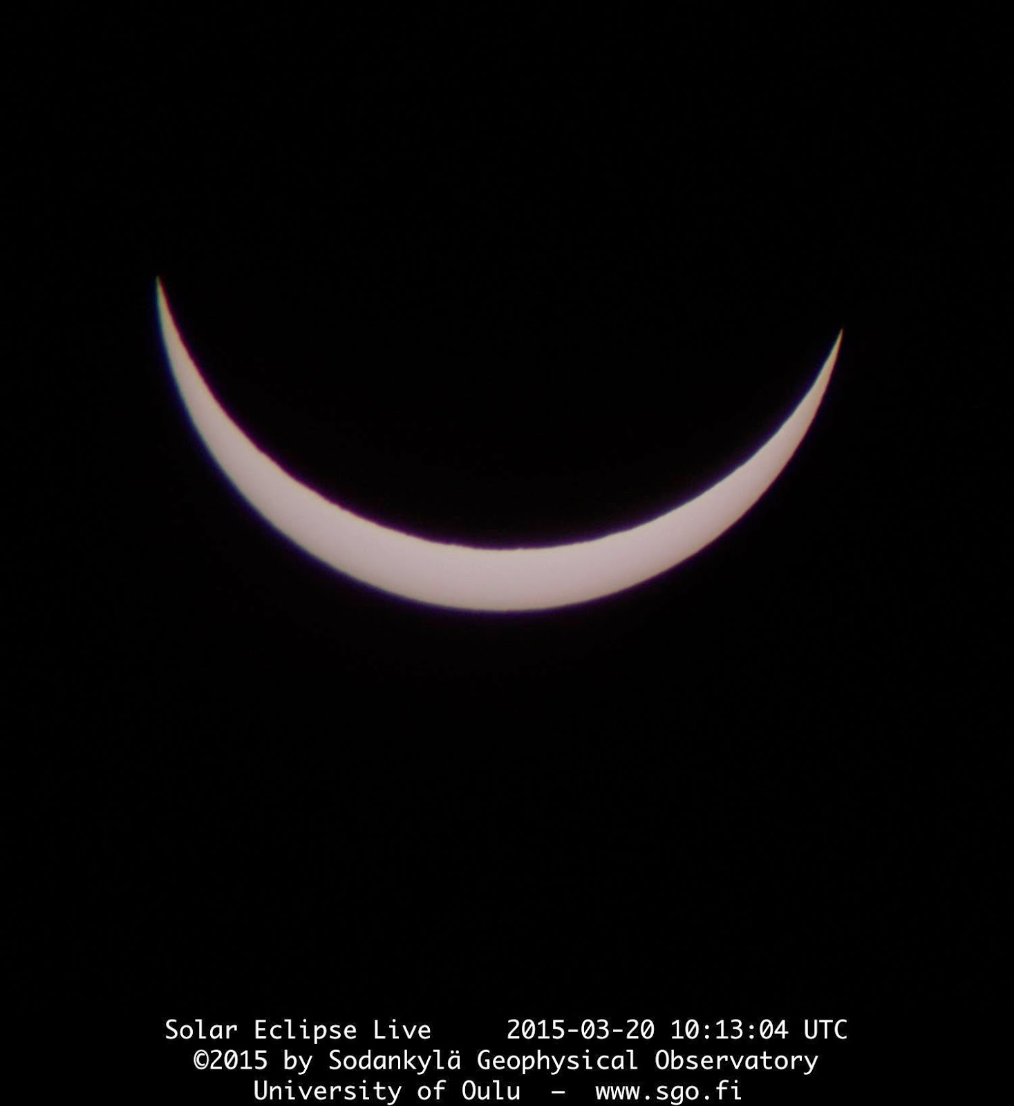
At maximum eclipse (pictured above), I finally check the images again – argh! Something in my script has started to do some automagic level adjustment, which leads to the black background becoming bright and noisy, which, in turn, causes the Sun-centering process to fail! Sorry about that, apologies to our viewers. But fortunately I've spotted it now and I am able to compensate by centering the Sun in the camera frame after every image. Some 10 minutes past the maximum, the Sun is bright enough again for my software to work fine, and the rest of the eclipse broadcast goes as planned. Phew!

In the end, the laptop has 30% battery left, and I took some 412 photos in almost continuous blue-sky conditions. Amazing. Suddenly it hits me: I haven't eaten since my small breakfast. Time to pack and head back and find some food – and coffee!

In the evening, back at home, I check the photos with my daughter, and wonder about the strange level adjustment, which happened between 10 min before and 10 min past the maximum eclipse. Finally I am able to track down the culprit: dcraw, the program that converts the raw images from the camera to something that ImageMagick can understand. By default, dcraw adjusts the levels of the images, and this default can be turned off by using option "-W". If only I had known that before the eclipse. Never mind, now I can re-calculate all the images, and see how it should've worked. Hmm... 412 images at 25 frames per second allows for a 16.5-second time-lapse of the eclipse: here it is. A bit wobbly, still, I need to improve my algorithm. But anyway, enjoy!

Thanks to all of you who tuned in to watch the eclipse on SGO's web pages. I hope you liked it. I certainly enjoyed tracking it down for you!

Photos: Thomas Ulich.

Thursday 19 March 2015

Eclipse live on 20th March

On Friday, 20th March 2015, there will be a solar eclipse, which can be seen as a partial eclipse (about 90% coverage) from Lapland if weather permits and it isn't cloudy. We will webcast the eclipse live as discussed previously. If the weather is cloudy, we will show the effect on the landscape, i.e. how dark it will really get.

You can follow the event on our web server at this address: http://www.sgo.fi/Events/Eclipse. At Sodankylä, the eclipse will begin at 11:08 h and end at 13:18 h reaching its maximum of just over 90% coverage at 12:13 h (all times East European Time EET).

Warning: Do not look at the Sun without special protecting solar folio or eclipse glasses! If you intend to use welding goggles, make sure they are at least factor 14 or darker (according to recommendation of the URSA Astronomical Association), and even with these glasses, one should not look at the Sun continuously for more than a few minutes! Standard welding glasses are typically 9 to 11 darkness, which is not enough! The sunlight can destroy your eyes, and you won't notice it at the time of observation, but only afterwards.

The Royal Astronomical Society has a comprehensive guide on-line on how to watch the Sun safely, e.g. with filters or pinholes.

Suomeksi: Tietoa pimennyksesta Suomeksi: URSA:n sivuilla. Pimennys voi seurata livenä osoitteella http://www.sgo.fi/Events/Eclipse jos pilvitilanne sallii.

Lue myöskin Lapin kanssa täällä.

Animation: Thomas Ulich.

Wednesday 18 March 2015

CME Impact as seen from KAIRA

All day yesterday (17th March), the space environment around Earth was being blasted by a CME which launched from the Sun a few days previously.  The solar wind speed measured just upstream from the Earth reached 500-600 km/s and the interplanetary magnetic field stayed southwards with values of -15-20 nT.  All this resulted in spectacular displays of aurora visible across the whole of Fenno-Scandinavia and at least as far south as Wales in the UK.  Here at Kilpisjärvi it was, naturally, cloudy and snowing all night...  However, KAIRA was observing as usual and the beamlet statistics indicate a very nice set of data!
The plot is of data from all beams in the current standard background task experiment (including a number of riometry beams covering the sky, a beam on the strong radio source Cas A and a beam on the Sun or a pulsar depending on whether or not the Sun is up).  The beam on Cas A is the most obvious as it is the one with all the scintillation!  However, of great interest to a number of SGO researchers are the darker vertical stripes, consistent over all the beamlets (which means all the beams in whichever direction they're pointing).  These are likely to correspond to strong riometric absorption events.  Some of them can be seen to be "wobbling" a bit in time, indicating some movement of absorption patches across the sky.  This will be a very interesting dataset indeed!